Epic Hiking Trails Around the World
If you love exploring the outdoors and experiencing stunning views of mountains, waterfalls, meadows, forests and lakes, you need to find yourself walking on one of these incredible hiking trails from around the world!
Nothing quite compares to getting out and exploring new territory, and no matter if your idea of an epic hike involves a mountain walk along the coast, breathtaking views, challenging terrain, or chasing waterfalls, this list has you covered.
Whether you’re an expert hiker or someone who has recently discovered a passion for the outdoors, these epic hikes will inspire you to explore the world – one step at a time!

This post contains affiliate links which means I earn a small commission if you purchase through one of my links at absolutely no additional cost to you. Feel free to read my disclosure policy. Thank you for supporting my blog!
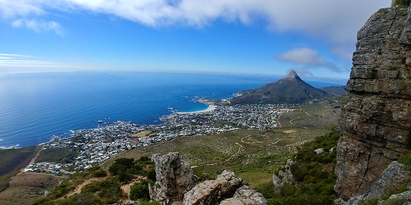
The Kasteelspoort route up Table Mountain, South Africa
Recommended by Rosanna Etc.
The Kasteelspoort route is one of the most popular hikes up Table Mountain in South Africa. Whilst challenging, it is not as steep and direct as other routes and is therefore a more enjoyable way to the summit and has stunning scenery.
The Kasteelspoort route up Table Mountain is approximately 6km and takes around 4 hours depending on how many stops you make along the way. It sets off from the Pipe Track Entrance in Camps Bay near Cape Town and ascends up the western slopes, with breathtaking views across the Lions Head and Atlantic Ocean. It is a beautiful hike with awe-inspiring rock formations and even an old cable car ruin that is the ideal place to stop for a rest or a picnic.
The best time to hike the Kasteelspoort route is early in the morning as it is mostly in shade at that point which provides some respite from the heat of the sun especially in summer months when temperatures soar. The route is composed in parts of a jeep trail, single rocky track, stone steps, ladders and more open terrain and hikers will need a relatively good fitness level to attempt it.
After heading through the Valley of Red Gods and into the Valley of Isolation you will find the Upper Cable Car Station where there is a tourist centre, restrooms and a café where you can enjoy views across Cape Town itself before riding down.
Bring: comfortable shoes, sunscreen and water
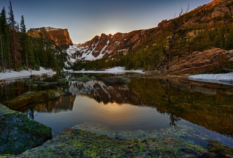
Emerald Lake, Colorado
Recommended by Meg of Fox in the Forest
Known as one of the most beautiful hikes in Colorado, the Emerald Lake trail is a must for anyone keen to explore Colorado’s stunning mountain scenery.
Despite the fact that the hike is relatively short and sweet (3.6 miles out and back), what makes it so epic is the fact that it boasts some of Rocky Mountain’s most iconic views and a backdrop of gorgeous mountain scenery that will have you drooling every step of the way. A few of the hike’s highlights include three dreamy alpine lakes, distant waterfalls, wildflowers, and views of Long’s Peak far off in the distance. Moreover, if you start the hike early in the morning, you have pretty good chances of spotting a variety of wildlife, including deer, bears, and elk!
Aside from the three main alpine lakes you’ll get to see along the trail (Nymph Lake, Dream Lake, Emerald Lake), you can also continue another two miles to Lake Hayiaha, which provides a much quieter spot to admire the views as not all hikers venture there.
Tip: As one of the most popular Colorado hikes, Emerald Lake can get pretty crowded, especially if you’re visiting during the summer months. For the best chances to get a quieter experience, it’s imperative that you start the hike as early as possible. Not only will this give you the chance to enjoy the views without tons of people around, but you’ll also get the added bonus of having wildlife encounters while hiking!
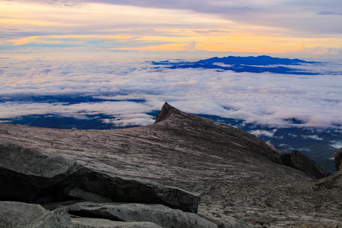
Mount Kinabalu, Borneo
Recommended by PlacesofJuma
One of the best hiking trails in the world is definitely the imposing Mount Kinabalu in Borneo (Malaysia). This spectacular 4,095-metre mountain is one of the highest in all of Southeast Asia and one of Malaysia’s most important landmarks too. If you are travelling through Borneo and are reasonably fit, you should not miss the climb!
Mount Kinabalu has been on the UNESCO World Heritage List since 2000, thanks to its unspoilt nature and beautiful mountain scenery. One more reason why hikers from all over the world come to climb this mountain.
Guided 2-day tours are offered every day. These are compulsory – hiking on your own is not allowed. The trip always starts in the morning around 9 am. At this time the weather is stable, in the late afternoon it usually rains. During the hike you can admire many different landscapes and vegetation: deep, lush jungle with carnivorous plants to the bare rock plateaus towards the summit. The first stage takes about 4-5 hours and you stay overnight at the Laban Rata mountain station, where you also have dinner.
The next day, the hike starts at 1 a.m. because the goal is to reach the 4,095-metre summit by sunrise. The effort is worth it, because this sunrise is a real experience! Then it’s all the way back to the valley station. You can plan on around 8-10 hours for this walk. The entire hike is neither very demanding nor dangerous. The best is, even inexperienced hikers usually have a successful ascent.
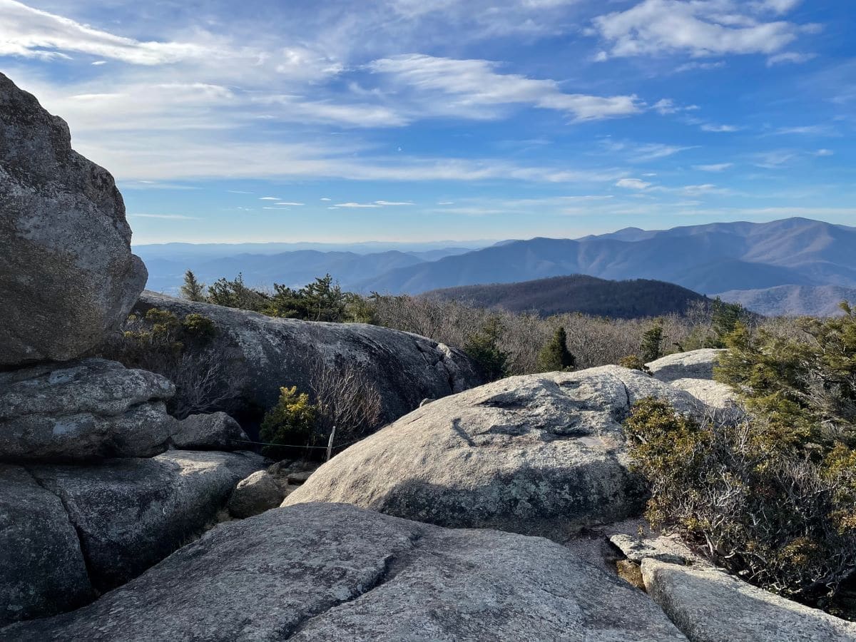
Old Rag, Virginia
Recommended by Erin of Go Hike Virginia
The exhilarating 9.8-mile Old Rag hike at Shenandoah National Park in Virginia, USA is a wildly popular bucket list hike that wows with stunning 360-degree panoramas from the wide-open rocky summit. While this hike is a crowd-pleaser, it’s not for everyone.
For starters, the elevation gain tops 2,600 feet, which is a challenge for many hikers. A mile of this hike is a rock scramble that requires hikers to navigate tight spaces, strategize rocky passages, slide down granite surfaces and dig deep to climb up onto rocks and boulders. You will, however, realize it was all worth it when you arrive at the top of Old Rag and revel in the far-reaching mountain vistas.
There’s plenty of room to sit, snack and savor the spectacular views across the Shenandoah Valley. From here, the trail descends to reach Byrd’s Nest Shelter, a day-use shelter with a picnic table. In a few more steps, you’ll arrive at Old Rag Shelter, another day-use shelter with a wooden picnic table. Near the end of the hike, you will stroll alongside gently flowing Brokenback Run. It’s a refreshing way to end your hike to Old Rag.
While the majority of hiking trails at Shenandoah National Park are accessed via Skyline Drive, the 105-mile scenic byway that runs the length of the park, Old Rag is not one of them. This hike begins at a parking area on the outskirts of nearby Sperryville, guiding hikers into the park from the eastern boundary. In 2020, a large new parking lot opened, allowing more hikers access to this uber-popular hike.
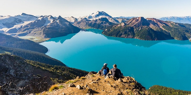
Garibaldi Provincial Park, British Columbia, Canada
Recommended by Mia of Walk a While with Me
For some of the most epic hikes near Vancouver, Canada, look no further than Garibaldi Provincial Park. Located 99 km (62 miles) from downtown Vancouver, it takes about an hour and 15 minutes to drive there, but it’s worth the commute.
With soaring mountains, enchanting meadows, and glacier-fed lakes filled with turquoise water, Garibaldi Provincial Park is one of the most beautiful places in British Columbia.
While there are many epic Garibaldi hiking trails, three stunning trails conveniently start on the same path: Panorama Ridge, Black Tusk, and Garibaldi Lake.
First, these hikes start with a tedious 6 km (3.7 miles) of switchbacks through the dense forest. However, upon accomplishing this first section, you’ll instantly be greeted with the magical scenery of Taylor Meadows. You’ll then split off into one of the three hikes:
– Panorama Ridge offers breathtaking panoramic views of Garibaldi Lake, Black Tusk, and Helm Lake. However, it is a difficult hike: 30 km (18.6 miles) long, 1520 m (4987 ft) elevation change, and an average 11 hours to complete (from the parking lot).
– Black Tusk is a difficult hike climbing the eroded remains of an ancient volcano. It is 29 km (18 miles) long, with 1640 m (5709 ft) of elevation change, and also taking an average 11 hours to complete (from the parking lot).
– Garibaldi Lake is the easiest of the three hikes (but still intermediate), leading you to an awe-inspiring and vast turquoise lake. 18 km (11.2 miles) long and with 820 m (2690 ft) of elevation change, this hike will take around 5-6 hours to complete (from the parking lot).
While you can accomplish all these hikes within a day, the best way to experience Garibaldi’s epic scenery is by camping overnight! But you will need a camping permit.
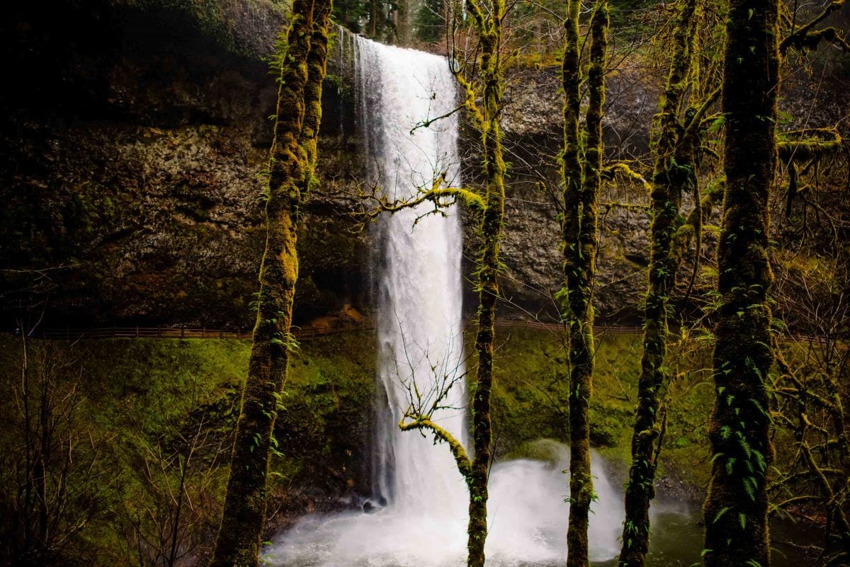
Silver State Falls, Oregon
Recommended by Emmy of Celebrate Again
Silver State Falls Hike is one of the many breathtaking waterfall hikes in Oregon, the best thing about this hike is that you can actually see up to 10 waterfalls if you do the full 8.6 mile loop.
However, if you’re looking for epic views that are accessible by wheelchair you can also stand at the cliff edge of the South Falls to see the gorgeous views.
Pets are allowed up to this point on the trail however most of the rest of the trails do not allow pets even on leash.
The beauty of Silver Falls State Park is that a few waterfalls are accessible and a few take a journey through the forest to view. It really is a perfect place for all explorers to enjoy the natural wonders of the waterfalls in Oregon.
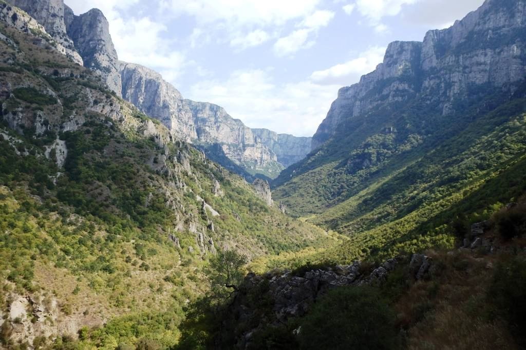
Vikos Gorge, Greece
Recommended by Chrysoula of Greece Travel Ideas
One of the best hikes in Greece is Vikos Gorge that is considered the world’s deepest gorge in proportion to its width. The Gorge lies in the Vikos Aoos National Park in Northwestern Greece near the city of Ioannina, and it is 20 km long.
There are many routes one can do but one of the most popular is between the villages of Monodendri and Vikos that is around 15 km long and takes around 6 hours to walk it. The trail starts at Monodentri village with a 45-minute descent to the bottom of the gorge, then the trail continues along dense forest with small ascents and descents.
One of the highlights of the route are the springs of Voidomatis river, one of the coldest rivers in Greece. The landscape is breathtaking with more than 1.800 plant species and the steep mountain tops surrounding the gorge. The trail finishes with a 1-hour ascent to Vikos village from where the views of the gorge are spectacular.
Please note that potable water can only be found in the middle of the gorge. In the surrounding area the visitor can find many outdoor activities like mountain biking, river rafting and rock climbing. There are also many traditional villages to explore and many stone arch bridges to discover.
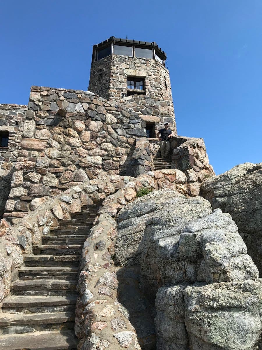
Black Elk Peak, South Dakota
Recommended by Ashlee of The Happiness Function
Does hiking to the tallest point east of the Rocky Mountains in the USA sound awesome? The hike to Black Elk Peak lookout tower, located in the Black Hills of South Dakota, is a bucket list hike for anyone who loves hiking.
To hike to the top of Black Elk Peak, take Sylvan Lake Trail #9, located in Custer State Park. This route is roughly 7.4 miles and takes about 3 to 4 hours to trek. The trail is well marked and maintained. Hikers will wander through thick pine forest with beautiful granite walls while passing by charming mountain springs along their journey up to the high point!
The route is moderately difficult since it gains 1,100 feet (335 meters) in elevation over 3 miles. There are also stairs to climb up once hikers get to the lookout tower. Once at the top of the mountain, visitors can see sweeping views that last all day long across South Dakota and Wyoming.
Plan to hike late spring through early fall (May through September). Since this is located in the Black Hills Mountain Range of South Dakota, at an elevation of 7,000+ feet (2,133+ meters), be sure to start hiking early in the day to avoid being up high during typical afternoon thunderstorms.
The Black Hills of South Dakota are known for being one of the oldest mountain ranges in the United States. There is so much to see and do in the area for any outdoor adventure lover. If planning a visit out west, be sure to add this epic trek on your best hikes around the world bucket list!
Snowdonia National Park, Wales
Recommended by Kerry of VeggTravel
Snowdonia National Park in North Wales is an awe-inspiring region in the UK. Not only do you have Mount Snowdon, the highest mountain in Wales, but you have dramatic views of the rural countryside in every direction.
Snowdonia stretches for over 823 square miles and has more than 100 lakes. As you can imagine, there are plenty of hiking trails to choose from, ranging from beginner hikes to the more extreme. However, one of the most epic hikes around the world has to be hiking Mount Snowdon itself.
There are six different paths to hike to the Snowdonia summit which are the Llanberis path, Pyg Track, Miners’ Track, Watkin Path, Rhyd-Ddu Path or the Snowdon Ranger Path. The easiest route is Llanberis path which is 9 miles and a 975m climb. All other routes are shorter but are a more strenuous climb. Whichever trail you choose will result in amazing views across the Welsh Valleys.
You can grab the Sherpa bus service between the trails and it operates frequently in peak season. Make sure you pack appropriately as the Welsh weather can be unpredictable at best. Be sure to look out for the rare Snowdon Lily as this is the only location this flower grows within the UK. It it s flowering plant with grass like leaves and you’ll find it on north-east facing cliffs.
If you are exploring the area and fancy taking an easier walk around the beach, woodland and Mediterranean inspired architecture, then head to nearby Portmeirion in North Wales. This makes a relaxing stop off to an otherwise adventurous trip.
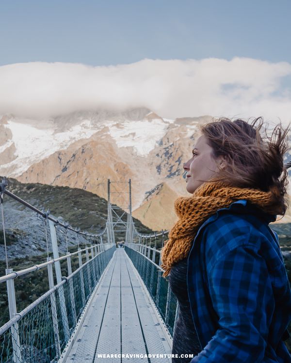
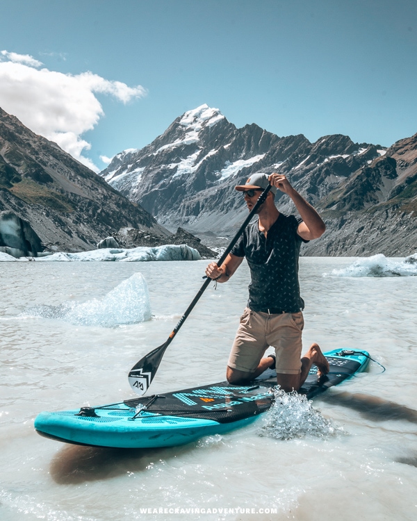
Hooker Valley, New Zealand
Recommended by Tom & Zi from Craving Adventure
The Hooker Valley Track is one of the most beautiful and most rewarding hikes in all of New Zealand. Some would even argue this is the single most rewarding half-day hike in the country! If you like incredible scenery, suspension bridges and want to see a real glacier then you must include Hooker Valley Track in your South Island itinerary!
The Hooker Valley is part of the incredible Mount Cook National Park, in the center of New Zealand’s South Island. To get there you’ll be driving past some of the bluest most breathtaking mountain lakes and your jaw might get blocked in a permanently dropped position before you even start hiking.
The Hooker Valley Track is a return track that starts and ends at the White Horse Hill Campsite, which is also a great place to stay if you’re looking to spend a few days in the area to do some more hikes in Mount Cook National Park. If you prefer staying in a hotel or hostel there’s some options in the nearby Mount Cook Village. You can easily drive or walk from the village to the start of the Hooker Valley Track, which adds about 30 minutes each way.
The Hooker Valley Track will take you through diverse landscapes, show you some incredible views and take you over many suspension bridges that make it even more unique. And just as you think it can’t get any better you’ll get to the breathtaking Hooker Lake at the foot of the iconic Mount Cook. New Zealand’s tallest mountain surely is an impressive sight, but what will draw your attention even more are the many mini icebergs floating in Hooker Lake and the giant glacier at the other end.
You’ll be hard-pressed to find a half-day hike in New Zealand that is as rewarding as the Hooker Valley Track.
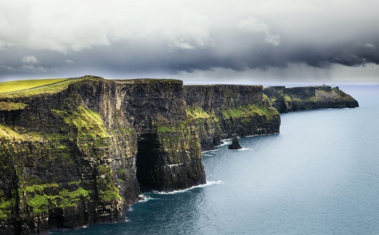
The Cliffs of Moher, Ireland
Recommended by Fiona of Travelling Thirties
Ireland is best known for its rugged cliffs, it’s green rolling hills and its beautiful hiking trials. There are many bucket list hikes in Ireland but one of the best hikes is the hike from Doolin to Hags Heads. The Hike from Doolin to the Hags Head gives you the most beautiful views of The Cliffs of Moher.
Located in Country Clare on the West Coast of Ireland on the famed Wild Atlantic Way. Over a million visitors a year head to the Cliffs of Moher, making it one of the most famous sites in Ireland, and for good reason too. The views over the rugged cliffs out onto the Atlantic Ocean can only be described as majestic.
While most visitors drive to the visitors Center and walk out to The Cliffs of Moher, the more adventurous travellers to reach the Cliffs and the Hags Head via the 14km hike from either Doolin or Liscannor. Despite the length of the hike it is fairly easy hike. Many sections of the path are flat, but it can become uneven at times. The most heart racing part of the hike is the fact that you are hiking along the edge of a cliff. The Cliff is as high as 214m in some places.
The other element of the hike that makes it challenging is the unpredictable weather patterns. One minute you might be hiking in the gorgeous sunlight, the next minute it might be blowing a gale and pelting down with rain. It is best to check the weather the day before and even the morning of the hike to ensure you are prepared for the weather. No matter the weather forecast, make sure you pack both a rain coat and a hat and plenty of water.
It is also recommended that you begin the hike early on in the day, you do not want to walking along the cliff edges in the dark. The hike will take around 6 hours, depending on how often you stop for photos and to take in the atmosphere. The hiking trail will become a little busy at The Cliffs of Moher viewing point/visitors center. Once you reach the Hags Head you can either hike the 14km back to town or you can take on the regular shuttles buses that run between the Hags Head and Doolin.
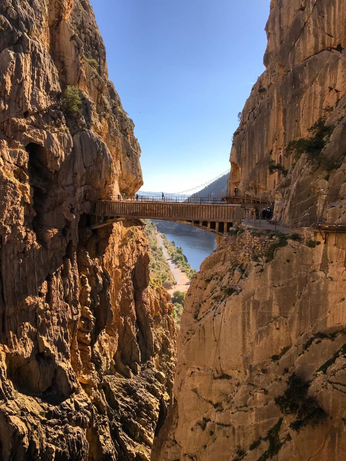
Caminito del Rey, Spain
Recommended by Victoria of Guide Your Travel
The Caminito del Rey is a spectacular canyon in the south of Spain which has become a popular hiking destination. It takes around an hour to drive from Malaga to the Caminito del Rey.
Keep in mind that tickets are required to hike the canyon since only a limited number of people are permitted to cross the small footbridges at one time. Tickets frequently sell out, especially on weekends and public holidays, so reserve your space in advance online.
The best way to get to the Caminito del Rey is by car. There is plenty of parking, and you will be able to take in the magnificent scenery and white villages along the road. There is also a direct train link from Malaga, which is a great choice if you don’t have access to a vehicle. After that, a shuttle bus will transport you to the start of the hike.
The hike is suitable for hikers of all levels of experience. Only a small fraction of it passes through the magnificent canyon and most is quite easy to manage. If you’re afraid of heights, this may not be the right activity for you though. The hike is not for the faint of heart because the drop is pretty steep. However, safety precautions are followed at all times, so there is no need to be concerned.
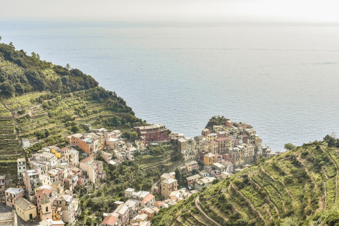
Sentiero Azzurro, Italy
Recommended by Em of That Travelista
Many of the most epic hiking trails around the world are entirely through nature, leading the hiker far away from the nearest city or town. But what if a hike combined the best of both worlds; stunning scenery with the most charming of manmade structures? Well, then that hike would probably be in the Cinque Terre.
Today, visitors to the Cinque Terre can move in between the five colorful villages by train or even car. But back when they were mere fishing villages, and not yet the major attraction they have become, the only way to travel between the Cinque Terre was on foot.
There is a significant network of 48 trails spanning 120 km (75 mi) and connecting the region, but the most famous is the Sentiero Azzurro, or Blue Trail. Sadly, reconstruction after a landslide has rendered its southern half closed for almost a decade. But luckily, there are other trails available to at least reach the second-to-last village, and they offer views that are arguably better than the main trail.
Completing the currently-open portion of the Sentiero Azzurro, plus the detour trail, spans a distance of 11 km (7 mi) and takes around 6 or 7 hours to complete. It is definitely possible to hike the Cinque Terre trail one day, although hikers often split it into two days, allowing more time to enjoy the villages along the way.
These villages are undoubtedly what makes hiking the Cinque Terre so epic. They make the perfect place to take a hiking break, grab a small meal (or at least a gelato!), and maybe even take a dip in the sea before heading back on the trail. While Cinque Terre often does not make it on to shorter first-time Italy itineraries, it is absolutely a must for those with ten days or two weeks in Italy.
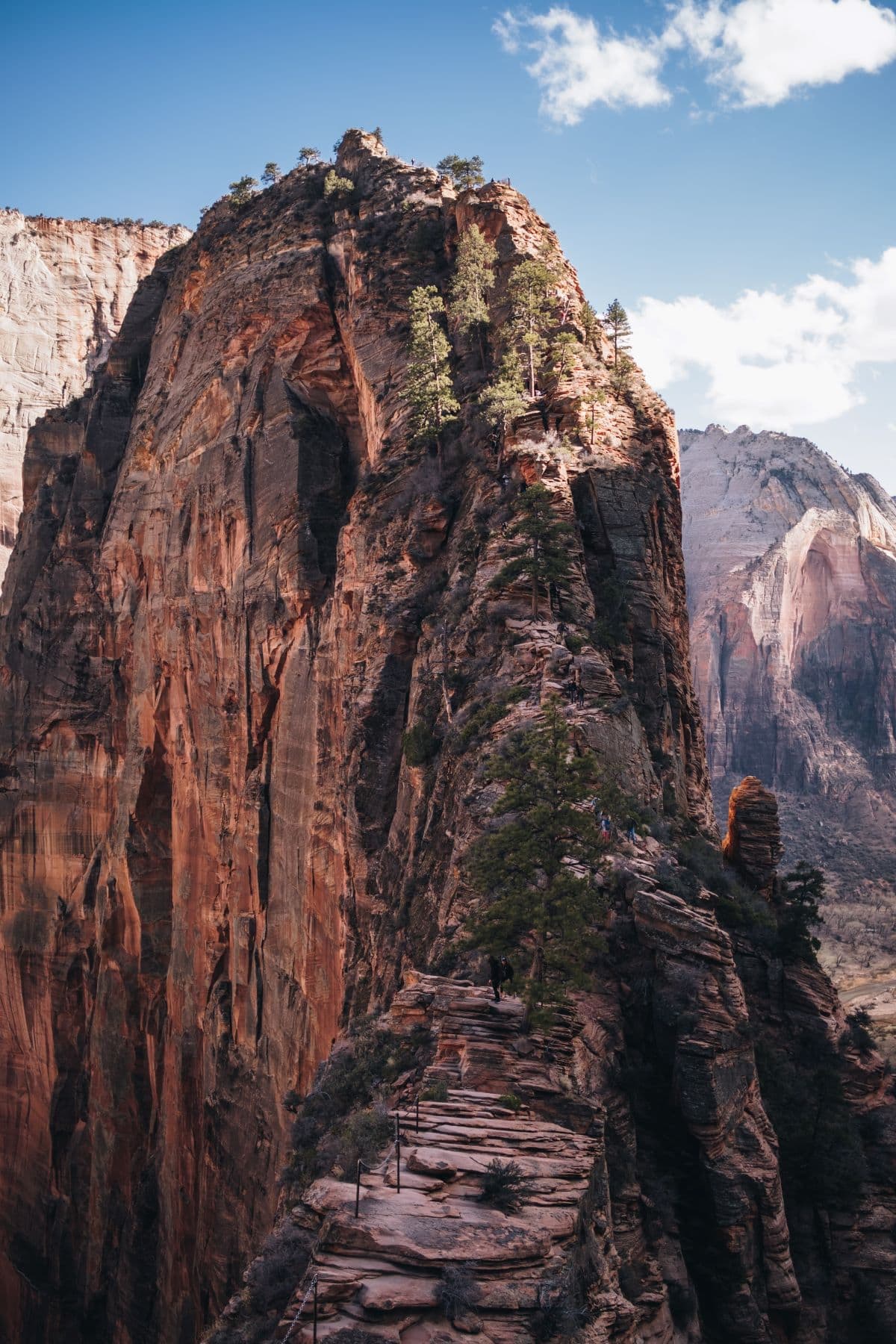
Angels Landing, Zion National Park, Utah
Recommended by Karen of Outdoor Adventure Sampler
Hiking up Angels Landing in Zion National Park in Utah often makes the list for the most epic hikes in the world. It’s for good reason that Angels Landing is so revered. The knife edge ridge along the top and the extreme exposure of the hike makes people with fear of heights tremble when they consider doing it. It’s certainly not for the faint of heart. The Angels Landing hike also makes the Outside Magazine list of the world’s 20 most dangerous hikes.
However, for experienced hikers, Angels Landing is a bucket list adventure. The 5-mile roundtrip hike starts at the Grotto Trailhead in Zion Canyon. The shuttle from the visitor center stops here to give easy access. Hikers usually take 4-5 hours for the trek.
The route follows the West Rim Trail into Refrigerator Canyon, a shaded side canyon. Walter’s Wiggles begin at the top of the canyon. These switchbacks scroll back and forth up the steep slope. Eventually you reach Scout Lookout with views of the precipitous Angels Landing rock formation. From here the trail climbs 500 feet with steep drop-offs on either side. The challenge of ascending steep slickrock using chains to prevent falling over the sheer drop-offs is exhilarating.
The views from the top of the fin-like formation provide a panoramic outlook over the vastness of Zion Canyon. The most pleasant time to hike Angels Landing is in the spring and fall. The popularity of the climb causes long lines of people to wait to do the hike. Try to avoid the crowds by going early in the day or in the off-season.
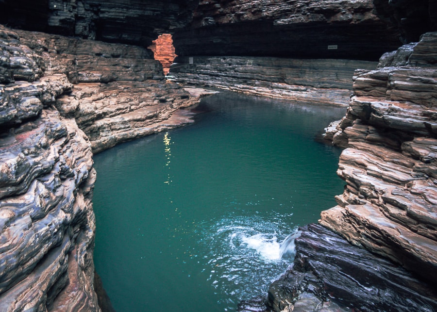
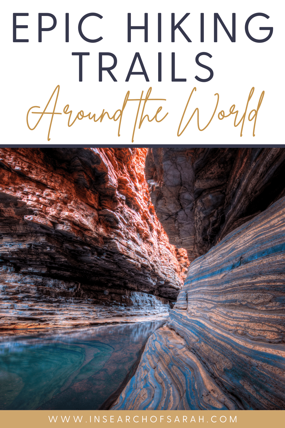
Karijini National Park, Australia
Recommended by Tess of Tessomewhere
Karijini National Park has some of the most unique hikes in Australia. Located in the Pilbara region in the north west of Australia, Karijini is well known for its incredible red gorges that you can hike through to fresh water swimming holes.
One of the most famous hikes is through Hancock Gorge. Whilst only a 1.5 kilometre return hike, it can take 2 hours due to the adventurous conditions along the trail. Start your hike with a descent down into the gorge via the metal ladder. From there, hike through the deep red rock walls of the gorge, at times having to climb along rocky ledges or wade through knee deep water.
The final narrow section of the Hancock Gorge hike is best known for the “spider walk” many hikers choose to do. This is where you shuffle or “spider crawl” along, arms and legs stretched out on both sides of the gorge wall to avoid getting wet in the gushing stream of water below.
After navigating this last tricky section of the hike, your reward is the picturesque swimming hole named Kermits Pool. Enjoy a refreshing dip in the cold waters here before returning back the way you came.
When hiking through Hancock Gorge or the many other gorge hikes in the park, make sure to use caution as lives have been lost in the gorges before. Due to the water crossings in Hancock Gorge it can get quite slippery, wear appropriate footwear when traversing the gorges.
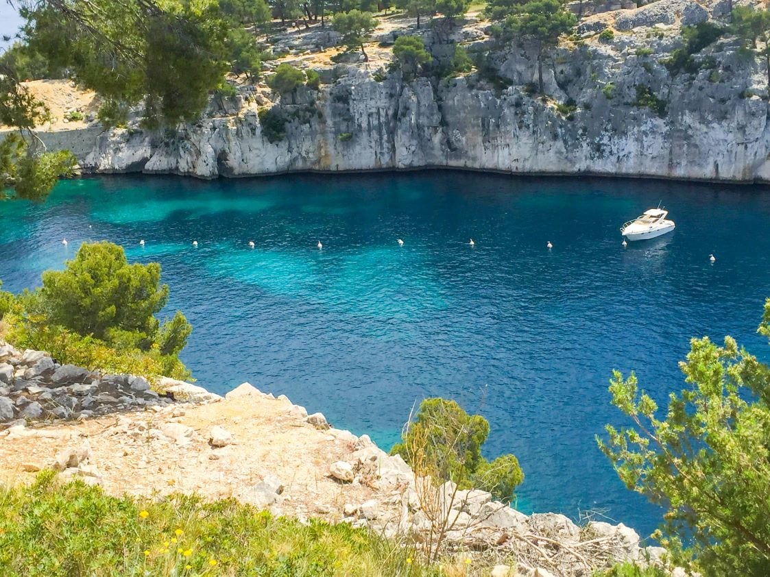
Calanques de Cassis, France
Recommended by Denise of Chef Denise
The Parc National des Calanques stretches 20 km between Marseille and Cassis, France. You can explore the Calanques by boat from either city, but the best way to see them is to hike.
What are calanques? Similar to Norwegian fjords, Calanques are narrow, steep inlets of limestone on the Mediterranean Coast that were formed over a million years ago. The rocky cliffs and vivid colors of the sea afford some spectacular views you can’t find anywhere else.
Start as early as you can in the fishing village of Cassis; you’ll get a jump on the crowds and heat. Even in the off-seasons it can be very warm, so make sure you have a hat, sunscreen, and plenty of water.
From Cassis you can hike to three popular calanques: Calanque Port Miou, Calanque Port Pin, and Calanque d’En Vau. Allow a full day to see all three.
You can reach the first calanque, Port Miou in about an hour. Just when you’re starting to wonder if you’re on the right trail, a winding emerald green waterway appears dotted with small boats. The path can be a little slippery and rocky in places, but for the most part it’s an easy hike.
Continue on to the even more scenic calanques of Port Pin and then d’En Vau where you’ll be rewarded with dramatic views and turquoise waters. If you need to cool off, plunge in at the small beach accessible from d’En Vau.
Besides the gorgeous Parc National des Calanques, this area is also known for delicious French food. After a day of hiking, indulge in a bowl of Bouillabaisse with crusty Provencal bread. You’ve earned it!
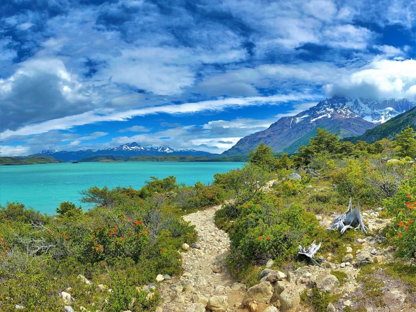
W Trek in Torres del Paine National Park, Chile
Recommended by Julia of The Cure for Curiosity
If you’re looking for one of the world’s most epic hikes, look no further than Torres del Paine National Park in the Patagonia region of Southern Chile. It’s home to the incredibly scenic, multi-day W Trek. This renown point-to-point hike takes you through 4 to 5 days of stunning mountains, turquoise glacial lakes, gushing rivers, calving glaciers, and more!
The W Trek clocks in north of 40 miles with ~10ish miles per day carrying your backpack. Fortunately, there’s not much altitude to battle, and you’ll be endlessly rewarded with new scenery. One day you’ll hike up to the famous Las Torres (The Towers), a set of jagged mountain tops situated over a lake. Another day you’ll hike into the center of the mountains past calving glaciers. There is no shortage of adventure in Torres del Paine where every place you go looks like a postcard picture!
As with every multi-day trek, there are a lot of logistics to figure out before you go. This is particularly true due to the limited accommodations in the National Park which means planning your W Trek in Torres del Paine early is important! Campsites or lodges may need to be booked up to 6+ months in advance to complete the route. This potential logistics challenge does come with some positives though. You won’t find overcrowded trails or even litter in the park. It’s just pure, untouched nature!
For the best weather, plan to hike between September and April which is spring, summer, and autumn in the area. Even in these “better weather” months, you are likely to encounter all four seasons on the trail, so be prepared. Wear well worn-in hiking boots and always pack rain gear, a pack cover, and lots of layers. And lastly, don’t forget your camera!
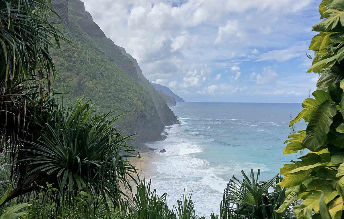
Kalalau Trail, Hawaii
Recommended by Nikki of She Saves She Travels
If you’re looking for the most epic hikes around the world, the Kalalau Trail in Kauai, Hawaii absolutely must be on your list! This incredible trail sits on the NaPali Coast, one of the most picturesque spots in the world, and one that simply begs to be explored.
The full Kalalau Trail is 11 miles long, or 22 miles round trip. It’s one of the most dangerous trails in the world, with backpackers hiking it over several days. Through thick vegetation and epic ridges, the trail zig zags through 5 lush valleys, next to jagged cliffs and across unpredictable streams that are often impossible to pass. The full hike requires a permit to hike and camp along the trail.
However, most visitors do the first 2 miles to Hanakapiai Beach, which is a much easier hike. This is perfect for visitors on vacation to Kauai that aren’t looking for a stenuous workout. Advance reservations are still required for the trail, as it’s located inside the Ha’ena State park and parking spots are limited.
Visiting in summer is the best time to go for weather conditions. The trail can be impassible during heavy rains, which typically occur more often during the winter months.
On the trail, you’ll be delighted with stunning views of the magnificent NaPali Coastline. After hiking steep inclines in thick jungle humidity, you’ll be rewarded with jaw-dropping scenery unmatched by any other on earth. It’s truly breathtaking!
Hiking the first 2 miles of the Kalalau Trail will take you to the Hanakapiai Beach, which is the perfect spot for a picnic or break to refuel on protein. The surf can be extremely rough on the north side of Kauai, and is not recommended for swimming. For most outdoor enthusiasts, hiking the Kalalau Trail is a bucket list activity.
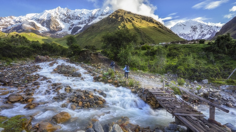
Salkantay Trek, Peru
Recommended by Shannon of Adventuring With Shannon
One of the most epic hikes around the world is the Salkantay Trek to Machu Picchu. This beautiful 36 mile hike takes you through the Peruvian Andes all the way to one of the greatest man-made wonders of the world: Machu Picchu.
Many people know of the Incan trail, but the Salkantay Trek is also an ancient Incan trail as well! While the Incan Trail itself is the religious route that the Incas would take from Cusco to their place of worship at Machu Picchu, the Salkantay route is the “commercial” route that they would take to ship food and goods from one location to another.
This hike is amazing because you not only get to see the incredible Andes, but you also get to scale the Salkantay mountain. The top of this mountain is higher than a 15,000ft elevation and is absolutely breathtaking. “Salkantay” means “The Savage” in the native Incan language, and that’s exactly what this hike is: Savage. This trek is generally rated as a four out of 5 on the difficulty scale so it is one that the average hiker would need to prepare for. Because the hike is above 10,000ft elevation, it requires a few days of altitude acclimation before you start the hike itself.
This hike is done in 3-5 days depending on your hiking pace. You must go with a guide or group tour on this trek due to environmental protection regulations in Peru. In this hike you will experience frozen mountain tops, incredible valleys, and even the outskirts of the Peruvian jungle. This trek ends at Machu Picchu where you get to experience this stone city built on a mountain top. It’s like nothing you have ever seen before. It is truly an epic experience to have.
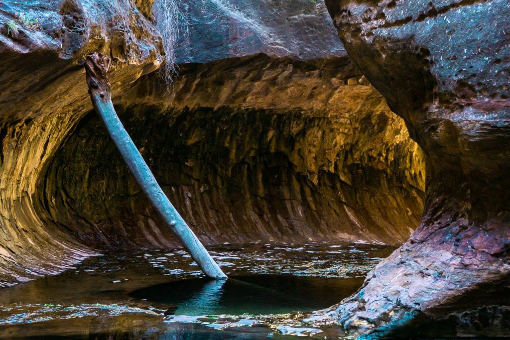
The Subway, Zion National Park, Utah
Recommended by Carrie of Trains, Planes and Tuk Tuks
When it comes to epic hikes around the world, it’s hard to top the Subway in Zion National Park in Utah, USA.
The Subway is a slot canyon named for its rock formations that look like Metro tunnels. The hike takes you from the canyon rim to the river where the canyon is widest, and you climb the rapids and cascades on the way to the slots.
The hike starts from the Left Fork trailhead, about a 30 minute drive from Springdale. A very competitive permit is required to access the area.
Almost immediately, you’ll endure a brutal, slippery, steep drop over 1,000 feet down to the river. Then the real fun begins. See, the Subway isn’t really a “hike” in the traditional sense. It’s more like an exploration of the river, where yes, you’ll occasionally walk. But more often you’ll rock scramble, swim, wade, waterfall-climb, jump and crawl on your stomach as you make your way to the cave. There is no trail — it’s entirely choose-your-own-adventure.
Along the way, you’ll be immersed in red rock country at its finest. Desert wildflowers abound. Elk graze in the fields. Desert waterfalls and rushing rapids form obstacles to be climbed up. Finally, after a final scramble up a stair-step waterfall, you reach the namesake rock formation.
When you finish exploring the cave, turn around and return the way you came. The total distance can range from 6-10 miles — the average is around 9.
Don’t be fooled by the modest distance — this hike is extremely difficult due to the tough terrain, and it’ll take you from dawn till dusk. Plus, you’ll want to take your time soaking in the raw beauty of the landscape, and you could spend hours exploring the Subway cave.
Santa Isabel Glacier, Colombia
Recommended by Venaugh
The Santa Isabel Glacier is one of six glaciers in Colombia and is actually a snow-capped volcano. It is 4,965 metres above sea level which makes for a difficult hike as there is less oxygen in the air at such high altitudes. There are also several other volcanoes within Los Nevados National Natural Park.
The park restricts the amount of people who can enter per day; therefore it should be booked in advance with a registered agency. The hike itself is 3.7 km which can take 3 hours going up, and another 2 hours to get back down. Some people extend this to 2 days so that more time can be spent on the glacier.
Along the hike, the “paramo” can be seen which is a treeless plateau. There are also different types of flora and fauna including plants which give off a scent that is said to assist with the altitude sickness. On the trail a small waterfall can also be seen.
Depending on the weather, there can be rain or snow so be sure to dress in warm clothing and preferable waterproof. After hiking through the cold and the altitude, there is a grand feeling of relief upon finally reaching to the glacier.
Hikers are allowed to climb on the glacier itself where you can even see the magnificent view of Nevado del Ruiz and the natural beauty of Colombia. Aside from the hike itself, a slight detour on the route will allow the Laguna de Otún to be seen which is also a great site for birdwatching.
Pin it for later!
Related Posts
- Cute and Cozy Hiking Inspired T-Shirts
- Tips on How to Prevent Tick Bites While Hiking
- Essential Hiking Gear for Beginners
- The Best Solo Hiking Tips
- The Most Beautiful Winter Hiking Trails in Niagara
- Where to See the Fall Colours in Niagara
- The Mysteries Behind Cave Springs Conservation Area
- Best Gifts for Hikers
Fab post Sarah! You are giving me such hiking wanderlust! I have only been to four of these so far (Garibaldi was last week) but I would looove to hike them all.
Caminito del Rey is an incredible hiking trail to go on! I hadn’t thought of going on a hike while in Greece before, so thanks for sharing that one!
Great list! I’ve tackled Snowdonia, and skirted the edges of Mt Kinabalu (and Everest). Hoping to try Northern Ireland’s highest peak next week, if no isolation pings come our way in the meantime. I’m looking forward to trying some more of these in the future.